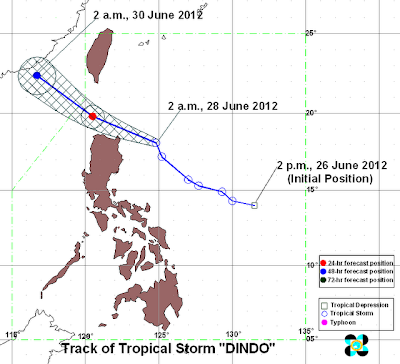
According to the Philippine Atmospheric, Geophysical and Astronomical
Services Administration (PAGASA), at 4:00am today (June 28), the center
of Tropical Storm "DINDO" was estimated based on satellite and surface
data at 260 km east Aparri, Cagayan (18.3°N, 124.4°E) with maximum
sustained winds of 75 kph and gustiness of up to 90 kph. It is forecast
to move west northwest at 19 kph. Southwest Monsoon affecting Southern
Luzon and Visayas.
2-DAY WEATHER FORECAST
Friday morning: 190 km North Northwest of Aparri, Cagayan
Saturday morning: 530 km Northwest of Basco, Batanes
Estimated rainfall amount is from 15 - 25 mm per hour (heavy - intense) within the 400 km diameter of the typhoon.
Friday morning: 190 km North Northwest of Aparri, Cagayan
Saturday morning: 530 km Northwest of Basco, Batanes
Estimated rainfall amount is from 15 - 25 mm per hour (heavy - intense) within the 400 km diameter of the typhoon.
Multiple tracks shows that it will hit Batanes group of islands or Cagayan provinces this coming June 28, 2012 (Noon to Evening) or morning of June 29, so it is better to prepare in advance to prevent damages and cost of lives.
Related Post: PAGASA Update: Bagyong Dindo (June 28)


Dindo now is already away from the country but we still experience rainfalls because of the low pressure area, looks like another typhoon will come again. We must be ready and alert to the news online and on TV to know the latest news about storm signals.
ReplyDeletePhilippine Storm